IT and geospatial data
Data processing, maps, web systems

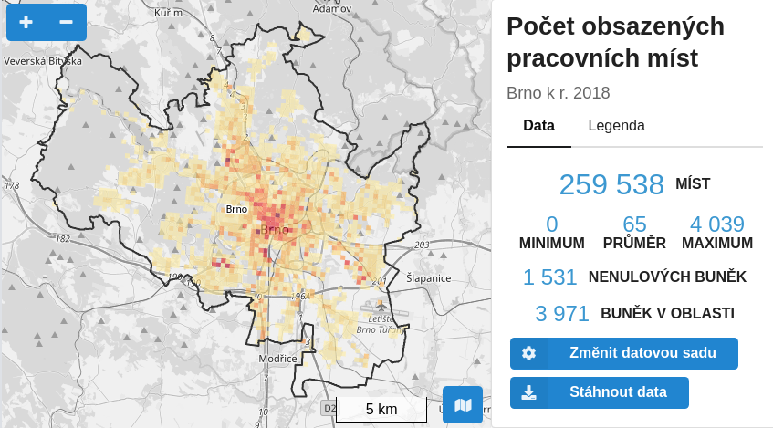
I can simplify spatial data management from its storage to publication as an interactive map or web application. I take care of map servers. Automation and optimization is my passion. I always try to get the best of both data and information technologies. Currently primarily under banner EnjoyChallenge.tech

Contact
Show case
Profile Picture

About me

I have 17 years experience in the field. I started as an employee of Masaryk University gradually as GIS specialist, developer, system analyst and finally the head of the GIS group at the Institute of Computer Science. For two years I have been maintaining the worldwide OpenMapTiles project for MapTiler. Since 2016 I work as full-time freelancer. In 2020 I started to cooperate with Michal Král. Currently we operate together under banner EnjoyChallenge.tech.

Selected work achievements

2023

2022

  • I participated in the extension of Layman service with publishing raster timeseries and data in various coordinate reference systems.
  • With Michal Král and the earth.guide team, we created a module for automatic tagging of photos. The photos are labeled as e.g. “forest”, “church”, or “waterfall”. We also improved their Android application with the possibility to share articles (in addition to photos), including their location on the map.
  • Under the banner of Altimapo, I cooperated on improvement of loading data for individual grid cells in BrnoUrbanGrid and on new portal DataMapo, grid statistics covering the whole Czech republic.
  • At the Institute of Geonics of the Czech Academy of Sciences, I taught publishing maps on the web for intermediate learners.

2021

2020

  • I led the first workshop about Layman service at Karel Charvát's Prague workshop.
  • I extended Layman service with automatically generated metadata records published via Catalog Service interface. I participated in the extension of Layman with authenticated access to the WMS and WFS interfaces using OAuth2.
  • I started cooperation with Michal Král.
  • I participated in the extension of BrnoUrbanGrid to the whole South Moravian region, including advanced generalization of grid data.
  • I created an interactive map of milestones for the Department of Landscape Ecology, RILOG.

2019

  • I have created five map applications showing protected areas for the project Landscape Dynamics Monitoring.
  • At BrnoUrbanGrid I linked up the URL to the status of the application, so it is possible to simply send links to specific map areas and data views, or go back in web browser history. More than 50 new datasets were added.
  • I extended the Layman service with the ability to publish map compositions and to authenticate users via the OAuth2 protocol.

2018

  • Together with Altimapo, we launched BrnoUrbanGrid, grid statistics of Brno city and Brno metropolitan area for both professionals and public.
  • I started working on the Layman service, which allows simple uploading of geospatial data from web browser to the server and automatic asynchronous processing of the data up to Web Map Service and Web Feature Service endpoints.
  • I created two landscape map applications for Department of Landscape Ecology, RILOG.
  • For MapTiler, I prepared two new releases of OpenMapTiles project. I extended the project with multilingual street names, multilevel road junctions, one-way roads, subway entrances, docks and indoor points of interest.

2017

  • For MapTiler, I prepared three new releases of the OpenMapTiles project, which allows you to host global maps on your own server in vector tiles format generated from OpenStreetMap data. I extended OpenMapTiles with geographical names in more than 50 languages, tens of thousands names from Wikidata, train stations, motorway links, runways, cable cars or mountain peaks.
  • I extended CzechGlobe aerial images with automatic checks and computation of area. I linked up the URL web application with its status, so it is possible to send links easily to specific map areas and data views, or to go back in web browser history. I also added lists of locations, campaigns, and datasets.

2016

  • At Institute of Computer Science, we have released the first version of munimap library that allows displaying interactive building and floor plans of Masaryk University on any website. Organizers of any event at the university can easily place an interactive plan on their website with a precise location of the room inside the building. This is probably the first similar service in the Czech Republic.
  • I left ICS after three years and started to work as freelancer.
  • I updated the CzechGlobe map server to support server-side rendering for better UX and SEO.

2015

  • We have extended Kompas system with tools presenting more than 240,000 technical devices. For example, users can easily find out which electric circuits are connected to which circuit breaker, or which water valve closes the water supply to the room where the pipe just broke.
  • In cooperation with the Institute of European Ethnology, we launched a public web system GISTraLiK, which provides information about traditional folk culture in Moravia between 1750 and 1900 through more than 60,000 records related to historical administrative units.

2014

  • At Institute of Computer Science, we launched a web system for facility management called Kompas whose development was started and led by me. Kompas brings users detailed passport data and plans of more than 20,000 rooms in 250 buildings. Kompas offers several times faster work with data, higher stability and efficient text search comparing to the previous application, which was built on pure ESRI technology. Today, Kompas has more than 1,000 users per year.

2013

  • I designed and created web presentation of paper map collection of the Department of Geography, Faculty of Science, Masaryk University. It includes intuitive search and display of scanned maps. The collection contains more then 2.300 maps and stil keeps growing.
  • After six years I left the Faculty of Science and started working for the Institute of Computer Science (ICS) at Masaryk University.

2012

2011

2010

  • As a freelancer and together with Věroš Kaplan I prepared and launched my first map server for CzechGlobe to publish aerial photography data. Ten years later server still running and publishes over 130 datasets with a total size over 40 GB.

2009

  • For the Czech Agriculture and Food Inspection Authority (CAFIA) I have prepared script that automatically paired addresses of more than 70,000 free text establishments with database of address points (now RÚIAN) with a success rate of 74% at the address point level and 98% to the municipality level. I saved CAFIA hundreds of hours of time of manual pairing.

2006–2008

  • I started to work as a GIS specialist for the Department of Geography, Faculty of Science, Masaryk University. I designed and partially implemented technical solution of the project Dynamic Geovisualization in Risk Management. For the first time I used GeoServer and got to know OGC standards: Web Map Service, Web Feature Service and Styled Layer Descriptor.

Contact me